

.jpg)
Timbuktu - Mali

In Danger since 2012
Website Category: Fortified Towns of the Trans-Sahara Trading Route
Area: unknown
Inscribed: 1988
Criteria: (ii) interchange of values (iv) icon of an era (v) interaction with the environment
Location and Values: Timbuktu is one of those iconic places in Africa, which has come to symbolise remoteness – the back of beyond. It was, in fact, a major trading and Islamic intellectual centre in the 15th and 16th centuries. Situated on the southern fringe of the Sahara desert in Mali the town prospered on the trans-Sahara trade in gold, salt and other products. The world heritage property covers the three main mosques (Djingareyber, Sankore and Sidi Yahia) and 16 cemeteries and mausolea at Timbuktu, which recall the town’s golden age, during the reign of the Askia (1493-1591; see also the Tomb of Askia profile).
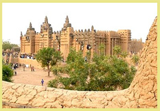
Slideshow of Timbuktu: The slideshow features 46 photos of Timbuktu from 1997. Only three of these give external views of one of the main mosques (Djingareyber Mosque), its mud walls piled with sand. It was one of the first mud-brick constructions (buildings had previously been constructed of mud applied directly to a wooden frame structure), dating from 1327 and extensively renovated and extended by Iman Al Aqib (1570–1583). The other pictures show some of the intellectual heritage of Timbuktu, including samples of ancient manuscripts held in the ethnographic museum there (the town was an important centre of Koranic culture with some 25,000 students from all over the region attending the university there). In the courtyard of the museum is the original Bouctou Well around which the town developed. Arriving by vehicle (as I did) involves a challenging drive through the desert sands, and a ferry crossing of the mighty Niger River. The local Tuareg will gladly escort visitors to one of their nearby desert encampments by camel, and entertain their guests with a traditional cup of strong mint tea. Back in the town, some buildings – ancient and modern – and even a stretch of tarmac road, are shown.
Slideshow of Timbuktu:
Google Earth View: To view satellite imagery of Timbuktu on Google Earth, click here. This opens a new window, so when you are finished, just close the Google Earth page and you will be straight back here to continue browsing. These are nice sharp images of the centre of the old town, including the three ancient mosques that are at the core of the world heritage property. It is worth taking a few minutes to explore the surroundings by panning around at different levels of resolution. That way, you’ll get a strong sense of ‘context’, understanding how this place is situated on the southern fringes of the desert with the Niger River some way to the south, providing a vital link with towns along its margins such as Mopti and Gao.
Links to other towns of the trans-Sahara trading routes: M’Zab I Ghadames I Ksour I Ait-Ben-Haddou
Other Links: Official UNESCO Site Details
 has many ancient manuscripts and artefacts reflecting Koranic culture")


