.jpg)
Virunga National Park - DR Congo

In Danger from 1994 to present
Area: 7,900 km2
Inscribed: 1979
Criteria: (vii) aesthetic; (ix) ecological processes; (x) biodiversity
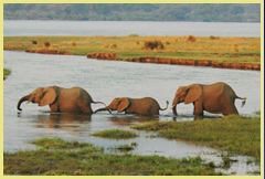
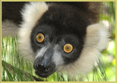
Values: Virunga National Park is Africa's oldest and most diverse park. Established in 1925, it straddles the equator, stretching from the lowlands at the bottom of the Rift Valley (680m) to the highest peak of the Rwenzori Mountains at 5119m. Its vast range of habitats includes rift valley lakes, swamps and acacia savannas, woodlands and forests, active volcanoes and rugged mountain slopes. The highest parts of the Rwenzoris support glaciers and snowfields on the equator, and the renowned volcanoes area bordering Rwanda and Uganda in the south supports half the world's mountain gorillas. The number of species recorded for different groups includes 218 mammals (including 22 primates), 706 birds, 109 reptiles and 78 amphibians. For comparative purposes, the number of bird species found in this park exceeds the total for the entire United States and is more than three times the number occurring in the United Kingdom.
Slideshow of Virunga National Park
 MAPS & SATELLITE IMAGES: A portfolio of maps and Google Earth satellite images is available for download by clicking here. The maps show the location of Virunga National Park in a regional context and the road network serving the area. The satellite images provide some informative perspectives on the park, showing the rugged topography in this part of Africa's western Rift Valley, the ecological isolation of the forested Virunga Mountains, the lava fields associated with the actove southern volcanoes and the Rwenzori Mountains further north along the eastern rim of the Rift Valley bordering Uganda.
Conservation News Updates
Global Witness report on oil exploration activities by London-listed FTSE250 company SOCO International in Virunga National Park (16 Marc 2012)
SOCO International website news story ‘Recognising opportunity’ for oil in Virunga National Park, planning aerial surveys over Lake Edward (14 March 2012)
UNESCO World Heritage Centre expresses concern about oil exploration in Virunga Park (13 March 2012)
Quick Reference Scores: (for explantion see About Us)
|
Scenery |
Wildlife/Biodiversity |
Accessibility |
Facilities |
Integrity |
|
|
|
|
|
|
Links: Google Earth | UNEP-WCMC Site Description |Official UNESCO Site Details | UNF Project | WWF Project | WCS Project | International Gorilla Conservation Project


