.jpg)
Okavango Delta - Botswana
")
Website Category: Wetlands
Area: 20,236 km2
Inscribed: 2014 (IUCN recommended)
Criteria: (vii) natural beauty, (ix) evolutionary processes, (x) biodiversity
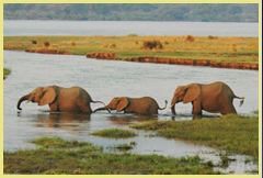
The delta is made up of permanent swamps, islands and seasonally-flooded grasslands which are a haven for wildlife. It is a natural oasis in which the perennial cycle of flooding activity continually maintains and shapes the ecosystem. Its waters originate in the highlands of Angola, arriving in the delta at the height of southern Africa’s dry season, providing a flush of new growth that attracts herds of elephants and grazing animals from a wide catchment area, at a critical time of year. There are few people, and the delta remains in pristine condition, mostly without roads or other forms of development. Moremi Game Reserve lies at the core of the world heritage site, with privately-managed Wildlife Management Areas making up most of the remainder. There are a number of luxury lodges within the delta, most of which are only accessible by private air charter.
Slideshow of Okavango Delta (for description see below):
Slideshow Description: The slideshow starts with a series of aerial views of the landscape across the delta from south-east to north-west. It begins with a view of the dry red Kalahari sands that dominate most of northern Botswana outside the delta, before entering the swamps and showing the flooded grasslands, meandering rivers, islands, stands of papyrus and other swamp vegetation, game trails and other features of the delta. Back at ground level, the water monitoring station at Shakawe is shown, as well as some of the ways people use the area’s abundant resources – bundles of cut papyrus (used for thatching), fishing, and tourist boating along one of the main channels of the inflowing river in the area known as the ‘panhandle’. Some of the prominent wildlife species are shown – from waterfowl to ground hornbills, elephants, lions, zebra, kudu and hippos, as well as the specially-adapted swamp antelope, the red lechwe. Finally a glimpse of traditional community life and livelihoods in the Khwai Development Trust area on the fringes of the delta is provided, where some intricate basket-ware is produced by highly-skilled local women.
 Maps and Satellite Images: A portfolio of maps and satellite images (from Google Earth) is available by clicking here. These show various aspects of the delta including the boundaries of the newly-designated world heritage site (and its buffer zone), the location of the site in a broader regional context, the extent of the river catchment feeding into the delta from the Angola highlands, the geological origins of the delta and road access to the area. The satellite images provide a superb perspective on the character of the wetlands and the diversity of habitats that make up the delta from the permanent swamps of the 'panhandle' to the dry woodlands that fringe the delta.
Google Earth View: To view satellite imagery of the Okavango Delta on Google Earth, click here. This opens a new window, so when you are finished, just close the Google Earth page and you will be straight back here to continue browsing. This window shows an overview of the fan-shaped alluvial delta during a low-water period, with the ‘panhandle’ (i.e. the swamps on either side of the main inflow) visible in the top left (north-western) part of the image. Zoom in to examine particular areas of interest.
Links to other places in the wetlands category: Banc D’Arguin | Lake Ichkeul | Djoudj | iSimangaliso | Sanganeb & Dungonab
Other Links: Google Earth | Official UNESCO Site Details | Birdlife IBA | Management Plan (2008, 216pp, pdf)
")

")
